Strymonas river belongs to the Balkan Peninsula and is 360 km long, of which 242 km are on Bulgarian territory and 118 km on Greek territory. In Bulgarian, the river is called Strumia, while during the Turkish occupation it was known as Kara-Sou. In Greek territory, the river flows solely in the territory of the prefecture of Serres and together with Aggitis river, which is its main Greek tributary, belong to the hydrographic basin of eastern Macedonia. It originates from Mount Vitaza, southwest of Sofia, Bulgaria, at an 2.2 km altitude. It flows south, initially very rapidly through ravines, then forms a fertile valley next to the Rila mountain range, while further south it creates a passage in the Pirin mountain range. Shortly before entering Greek territory, it merges with one of the most important tributaries, the Strumitsa, which originates from Mount Plakovitsa in the southeastern tip of Yugoslavia.
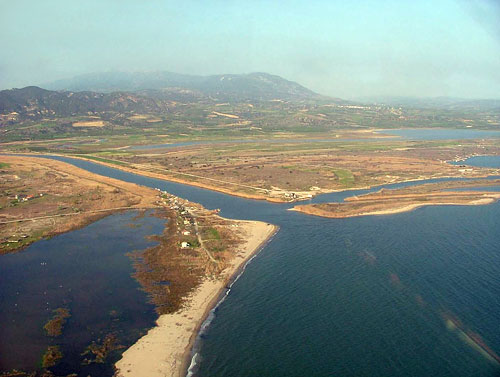
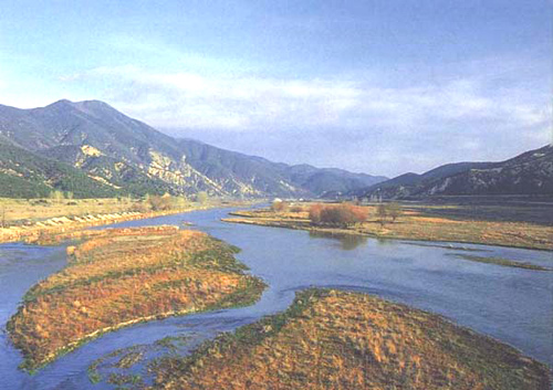
It enters Greece west of the village of Promachonas, through the narrows of Koula or Roupel, which the river itself has created between the mountain ranges of Kerkini (Beles) and Orvilos (Agistro). At this point, due to the abrupt change in the inclination of the land, the river loses its rapidity and divides into two main branches. The western branch flows into Lake Kerkini. It then flows southeast until it merges with the eastern longest branch. There, the river forms a single bed near the village of Lithotopos. From this point and for 50 kilometers till it merges with Aggitis river, the bed of the Strymonas river is artificial, with embankments and irrigation canals. This artificial bed was deemed necessary, because the shallow natural bed has been the cause of extensive floods in the past. The irrigation canals remove the excess volume of water and at the same time fertilize the plain. Strymonas river merges with Agitis river, which originates from the southern slopes of Mount Falakro, 5 kilometers before its (Aggitis) mouth. In this place there was the now dried Lake of Achinos. Finally, the Strymonas river passes between the Kerdyllio and Pangaeo mountains and flows into the Strymonikos gulf, east of the New Kerdyllia village, forming a small delta. The limited extent of the delta is due to the waves and the along-shore diffusion of the material carried by the river. In the past, its estuary used to be easterner than it is today.
The main Greek tributaries of the Strymonas river are the Butkovas which flows into the small valley of Poroia, the Exavis which originates from Kerdyllio, the Krusovitis which originates from the Orvilos and the Xropotamos that originates from Mavrovouni. The total catchment area of the Strymonas river has an area of 16,550 square kilometers, of which only 6,027 are in Greek territory. The river is rich in debris that continuously end up into the plain of Serres and Lake Kerkini. It is estimated that at least 4,000,000 cubic meters of debris are transported annually by an average annual runoff of 3.4 billion cubic meters of water. Its width exceeds 250 meters, while its depth reaches 3 meters.
On the Bulgarian territory there is a hydroelectric dam, while on the Greek side are several small dams for irrigation purposes but also to protect the existing bridges from water damage, but without blocking fish. The Strymonas valley is Bulgaria’s only communication channel with Greece as well as the Thessaloniki-Sofia road.
The rocks of its watershed consist of gneiss, shale and marbles. There are also igneous rocks and sedimentary minerals. Small gold reserves can be found in some areas of its bed.
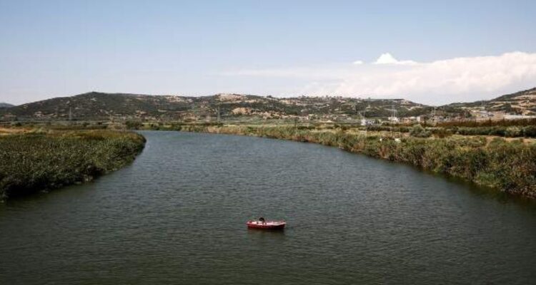
On the banks of the river is a variety of aquatic vegetation, such as shrubs. There are mostly elms, willows, acacias and plane trees. Also, there are several species of fish living in it, of which carp is the most common, but also fish that are in smaller quantities such as rutilus, european perch, catfish and eels. The fauna of the river’s ecosystem is completed by a multitude of animals and birds that nest on its banks and are directly dependent on it.
The river crosses sparsely populated areas in the Bulgarian territory, while its narrow valley does not allow the extensive use of agricultural drugs and fertilizers. Thus, when it enters Greece it has zero pollution. However, the river gets slightly polluted by the use of fertilizers and industrial waste from small factories in the area of Serres,
Copyright 2023 © Created By Diadyktio, All Rights Reserved.
To provide the best experiences, we and our partners use technologies like cookies to store and/or access device information. Consenting to these technologies will allow us and our partners to process personal data such as browsing behavior or unique IDs on this site and show (non-) personalized ads. Not consenting or withdrawing consent, may adversely affect certain features and functions.
Click below to consent to the above or make granular choices. Your choices will be applied to this site only. You can change your settings at any time, including withdrawing your consent, by using the toggles on the Cookie Policy, or by clicking on the manage consent button at the bottom of the screen.


Congratulation!