The current area of Sintiki was inhabited by the Sindus or Sindius, who started around the 19th century BC. from Sintiida, today’s Lemnos. This Greek race, after reaching the shores of Thrace, in the Strymonian Gulf, followed the flow of the river, which in those years was the natural route to the Balkan countries.
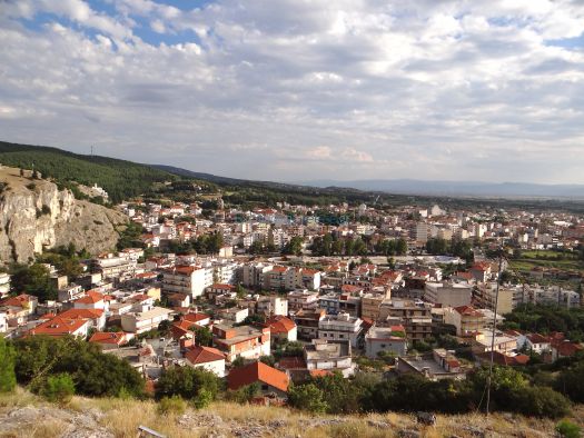
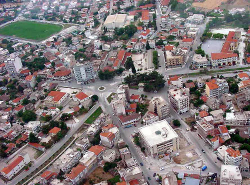
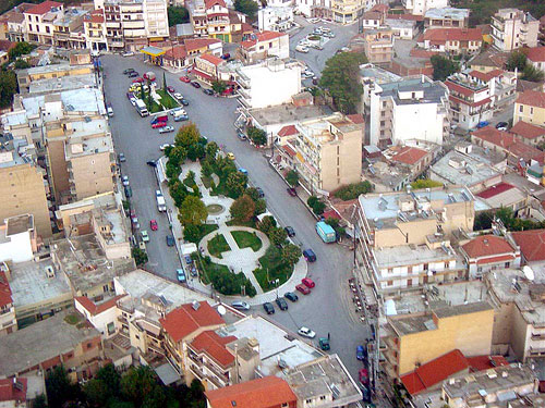
30 towns and villages are part of Sintiki. Sidirokastro is built on the banks of the Krousovitis River. With a population of 11,000 inhabitantsand it is 24 kilometers away from Serres and 24 kilometers away from Promachonas and the Greek-Bulgarian border. Sidirokastro is a road, rail and energy hub that connects Greece with the Balkans. It is an area that’s constantly developing, both commercially and urbanistically. Modern high-rise buildings appear in central parts of the city and transforming it into a modern growing European city. However, the traditional architecture of the old buildings, which proudly stand out in every corner, take us back to bygone eras and preserve the Greek style in the area.
Sidirokastro owes its name to its rocky fortress(build by Vasilios the Bulgar-killer), Issari, which stands on the northwest of the city at an altitude of 155 m. During the Turkish occupation, Sidirokastro became a center of Hellenism and heroically resisted during the Macedonian Wars. Ruins of the city’s castles are still preserved on Issari. Inside a castle, there is a huge brick crock, something like a cistern, where water was collected to be used in times of need.
The peple of Sidirokastro are a mixture of locals and refugees from various places, such as Asia Minor, people who came in 1913 from Meleniko, the Thracians who came from Eastern Thrace in 1922 after the Asia Minor Catastrophe (Greco-Turkish War), the Pontians from Pontus and others. Sidirokastro was liberated from the Turkish occupation on 27 June 1912. After that, it was under the Bulgarian occupation for 8 months, until it was finally liberated on 27 June 1913. Every year on June 27th, Sidirokastro celebrates this anniversary.
During the summer seasons, the most common place for meeting and walking for locals and visitors, is the Krousovitis Valley. Krousovitis is the river that runs through the town of Sidirokastro.
Krusovitis, a tributary of Strymonas river, divides the valley into two parts joined by picturesque bridges. The two largest bridges are of Stavros and Kalkanis.
Leaving the bridge behind, the area next to the river has been suitably designed as a place for recreation and walking. However, the area that offers visitors landscapes of exceptional natural beauty is the “Mavros Vraxos (Black Rock)” and the “Zesta Nera (Hot Waters)”, located north-northeast of the city. Natural waterfalls, water mills (of which only the ruins have been preserved), two small dams, built by the Forest Service, that form small lakes, are surrounded by rich and dense vegetation.
The old castle in Sidirokastro is preserved to this day. The church of Agios Dimitrios is carved into a rock in this pine-covered area. The Cincture of the Theotokos is kept in the sanctuary. On the northern side of the city, there is the “Sotira” (Savior) or “Top-Bair” (hill of the cannon) hill with the chapel dominating above them. The name “Top Bair” originates from the fact that during the Turkish occupation, the Turks erected a cannon on top of the hill. This is where the motto for Bayram and Ramadan was given. In Sidirokastro you will also find the Holy Monastery of St. Cyricus and St. Julitta, built on the southwest side of the rock in 1967 by Metropolitan Ioannis.
On your way to the northwestern part of the prefecture, you can visit Neo Petritsi, which is 32 km away from Serres. The road, with the wonderfull landscape, will lead you to Lake Kerkini. One of the few wetlands in Greece. Enjoy your coffee or lunch overlooking the lake at Lithotopos. A trip to admire the wonderful scenery of Mount Belles, north of the lake, can be also planned too.
The Vyroneia Railway Station, built in 1896, was the headquarters of the greek military headquarters during the last phase of the Second Balkan War (1913). The bronze inscription on the century-old plane tree reminds us that here, the King Constantine and the Prime Minister Eleftherios Venizelos drew up the terms of peace against the defeated Bulgaria.
Akritohori is built on the green foothills of Mount Belles and is located at an altitude of 130 meters above sea level. The International Path E4 – 6, that passes through the Akritoxori village, ends at the Strymonas river bridge. Akritochori is known all over Greece for the Holy Monastery of Saint John the Forerunner, an exact copy of the architecture of Mount Athos. North of the Hermitage is an artificial lake with spring water where fishing is permissible.
Mandraki was built on the north side of Lake Kerkini and at the foot of Mount Belles, at a 50 meters altitude. Based on archaeological evidence, the ancient city of Sindia was located near the village (remains of an ancient wall were found at the eastern entrance of today’s village). The village is the main access point to Lake Kerkini, with the little harbor it has for touring the habitat with traditional plavas.
Neo Petritsi is built on the south-eastern foothills of the Belles mountain range at an altitude of 100 meters .The main feature of the area is the green valley of Londza with its century-old plane trees and the flowing waters of Sultanitsa. North of the village is the Istibei fort,part of the fortified “Metaxa Line”.
Megalochori village is built on the banks of the river Strymonas at an altitude of 35 meters. The village is an access point to the habitat of Lake Kerkini and the bird nests forest. At the “trigono”(triangle) location, the visitor can see the lakeside forest, the various birds living there and the ruins of the village that was built for the needs of the film project of th. Angelopoulou “The Weeping Meadow”. Also, here, the visitor can observe the largest number of buffaloes in Greece.
Gonimo village is located south of the river Strymonas and at a lower altitude than its bed. For this reason, its bed has been properly adjusted in the 1970s to avoid floods. In the forest is an organized recreation area, with a football and basketball court.
Copyright 2023 © Created By Diadyktio, All Rights Reserved.
To provide the best experiences, we and our partners use technologies like cookies to store and/or access device information. Consenting to these technologies will allow us and our partners to process personal data such as browsing behavior or unique IDs on this site and show (non-) personalized ads. Not consenting or withdrawing consent, may adversely affect certain features and functions.
Click below to consent to the above or make granular choices. Your choices will be applied to this site only. You can change your settings at any time, including withdrawing your consent, by using the toggles on the Cookie Policy, or by clicking on the manage consent button at the bottom of the screen.


Congratulation!